


GLand: GPS Field Area Measure MOD APK 3.26.3 (Premium Unlocked)
Advertisement


Accurately measuring land and distance no longer requires expensive tools or complex calculations. GLand: GPS Field Area Measure brings a powerful, easy-to-use solution right to your smartphone. Whether you’re a farmer, real estate professional, or field engineer, this app transforms how you measure, record, and share land data — anytime, anywhere.
A Smart, Free Tool for Accurate Measurements
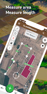
GLand is a free GPS-based measurement app that helps users measure area, distance, and perimeter with just a few taps. You can either pin points directly on the map or walk around the area in real life — the app automatically calculates the total land size for you.
It supports a wide range of measurement units, including metric (meter, kilometer, hectare), imperial (feet, yard, acre), and even traditional Thai units like rai and wah. Whether it’s farmland, construction plots, or property boundaries, GLand ensures every measurement is accurate and effortless.
Multiple Measuring Modes for Every Need
GLand offers three main measurement modes designed for flexibility and precision:
- Length/Distance Mode: Perfect for measuring roads, irrigation lines, or fencing.
- Area Mode: Calculate the total surface area of fields, plots, or gardens.
- Coordinate Mode: Add and save GPS coordinates for easy reference later.
This versatility makes it ideal for agricultural planning, land sales, or real estate documentation, allowing users to measure any location directly from their phone or on-site.
Powerful Tools and Real-Time Collaboration
GLand isn’t just about measurement — it’s a complete field management toolkit. The app includes a compass, a coordinate converter (Geo, UTM, MGRS), and unit conversion tools for maximum convenience.
In its enhanced version, GLandGo, users can collaborate with their teams in real time. Share live measurement data, create shared workspaces, sync projects via cloud storage, and even leave comments or notes for better team communication. This feature increases productivity by up to 40%, reduces errors, and allows seamless collaboration — even when team members are miles apart.
Professional Export and Data Sharing Options
Once measurements are complete, GLand lets you export your data in multiple formats, including PDF, Excel (XLS), KML, and GeoJSON. These files can be used for real estate reports, land sale listings, government submissions, or environmental studies.
You can also share visual maps and measurement results via social media, email, or instant messaging. The app even supports exporting map images, elevation details, and GPS-tagged photos, helping professionals create comprehensive land documentation in minutes.
Designed for Real Work – Online and Offline
One of GLand’s biggest strengths is its offline functionality. Even in remote rural areas without an internet connection, the app continues to operate seamlessly using GPS signals.
It supports multiple map layers, including Google Maps, satellite imagery, WMS layers, and rain overlays, so you can view land data from various perspectives. Farmers, surveyors, and agents can even create multiple projects, store unlimited data, and manage them efficiently from a single dashboard.
Why GLand is Trusted by Over 7 Million Users
GLand’s simplicity and precision have made it a favorite among over 7 million users worldwide. From small farmers mapping their fields to property developers planning large-scale projects, everyone benefits from the app’s intuitive design and reliability.
Key benefits include:
- 100% free to use – no costly subscriptions required.
- Accurate GPS measurements for any type of terrain.
- Offline support for on-site fieldwork.
- Multi-format exports for professional documentation.
- Real-time collaboration and cloud sync with GLandGo.
With continuous updates and support for modern map technologies, GLand stands as one of the most reliable land measurement apps available today.
Final Thoughts
If you deal with land, property, or agriculture, GLand: GPS Field Area Measure is an essential tool in your toolkit. It combines accuracy, convenience, and innovation — helping you measure, analyze, and share land data in just a few taps.
Download GLand for free today on Android or iOS and experience the smarter way to measure land!
Start mapping your world with GLand: GPS Field Area Measure — because precision matters.
Advertisement
Additional Information
- Version 3.21.4
- Requires Android 5.0+
- Update October 20, 2025
- Developed by Maps Tools Utilities Team
- Google Play ID com.gis.toptoshirou.landmeasure.Glandmeasure
Advertisement


